
Stedman Whitwell’s Rational System of Nomenclature
Back in the 19th century, English architect Stedman Whitwell decided that there must be a way to name cities and towns that could not only provide a unique name but also convey geographic information. His idea, as described by George Browning Lockwood in The New Harmony Communities (1902):
I think the chart above is slightly misleading, as it implies that the top line is for latitude and the bottom for longitude. But if you look at the names Whitwell was coming up with, it's clear that this wasn't the case. It seems, instead, that one had to choose whether to start the name with a vowel (top line) or consonant (bottom line).
If I've understood his system correctly, then the 'rational' name for San Diego (32.71 N, 117.16 W) could be Fena Baveeby. And Los Angeles (34.05 N, 118.24 W) could be Fotu Avapek.
Whitwell noted some of the incongruities in American nomenclature, and deplored the repetition which was producing “Washingtons” and “Springfields” in every state in the Union. He proposed to give each locality a distinctive name by expressing in a compound word the latitude and longitude of the place, thus enabling one to locate any community geographically when the name was once known. Letters were proposed as substitutes for the numerals used in expressing latitude and longitude, as follows:
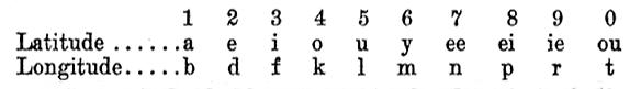
The first part of the town name expressed the latitude, the second the longitude, by a substitution of letters for figures according to the above table. The letter “S” inserted in the latitude name denoted that it was south latitude, its absence that it was north, while “V” indicated west longitude, its absence east longitude.
Extensive rules for pronunciation and for overcoming various difficulties were given. According to this system, Feiba Peveli indicated 38.11 N., 81.53 W. Macluria, 38.12 N., 87.52 W., was to be called Ipad Evenle; New Harmony, 38.11 N., 87.55 W., Ipba Veinul; New Yellow Springs, Green county, Ohio, the location of an Owenite community, 39.48 N., 83.52 W., Irap Evifle; Valley Forge, near Philadelphia, where there was another branch community, 40.7 N., 75.25 W., Outeon Eveldo; Orbiston, 55.34 N., 4.3 W., Uhi Ovouti; New York, Otke Notive; Pittsburg, Otfu Veitoup; Washington, Feili Neivul; London, Lafa Vovutu.
The principal argument in favor of the new system presented by the author was that the name of a neighboring Indian chief, “Occoneocoglecococachecachecodungo,” was even worse than some of the effects produced by this “rational system” of nomenclature.
I think the chart above is slightly misleading, as it implies that the top line is for latitude and the bottom for longitude. But if you look at the names Whitwell was coming up with, it's clear that this wasn't the case. It seems, instead, that one had to choose whether to start the name with a vowel (top line) or consonant (bottom line).
If I've understood his system correctly, then the 'rational' name for San Diego (32.71 N, 117.16 W) could be Fena Baveeby. And Los Angeles (34.05 N, 118.24 W) could be Fotu Avapek.


Comments
How bored and drunk does one have to be to create this system, eh?
agent j
agent j
Posted by agent j on 03/20/19 at 09:36 AM
Some of those names sound like the current crop of drug names one sees advertised on T.V. Perhaps this concept was noticed by someone making up the names?
And as for town names appearing where they don't belong, when I worked in Pittsburgh, PA, someone in the office spoke about driving in from Indiana every day. I thought he was actually driving across two states to get to work, until it was pointed out that there was a small town named Indiana nearby. When I looked on a map I found that there was also a town named California in the area, also.
And as for town names appearing where they don't belong, when I worked in Pittsburgh, PA, someone in the office spoke about driving in from Indiana every day. I thought he was actually driving across two states to get to work, until it was pointed out that there was a small town named Indiana nearby. When I looked on a map I found that there was also a town named California in the area, also.
Posted by KDP on 03/20/19 at 09:07 PM
Whitman was apparently drunk enough to be in denial of certain events of 1776-81, which indicated that the USA might not be very receptive to further ideas from the Brits.
Posted by Virtual on 03/21/19 at 10:08 AM
Very logical but also very impractical. There are far too few options for different letters For those where the first number is 32, for example, the names have to start with either Id... or Fe..., which means a line of towns which can only alternate their beginning.
Posted by Phideaux on 03/21/19 at 05:11 PM
Commenting is not available in this channel entry.
Category: Geography and Maps | Odd Names | Nineteenth Century